Where was he born?
The answer to that question is, as far as I can track down, rather surprisingly for 20th/21st century folk, we don't know.
I'm not even 100% certain of the year of young Lachie's birth. In all probability it was 1762, but at least one source says 1761. Okay, it's hardly incredibly important, but carelessness in minor matters can indicate carelessness with more major matters. As a historian, I can only try to be as honest as possible at all levels, otherwise whatever I write becomes suspect.
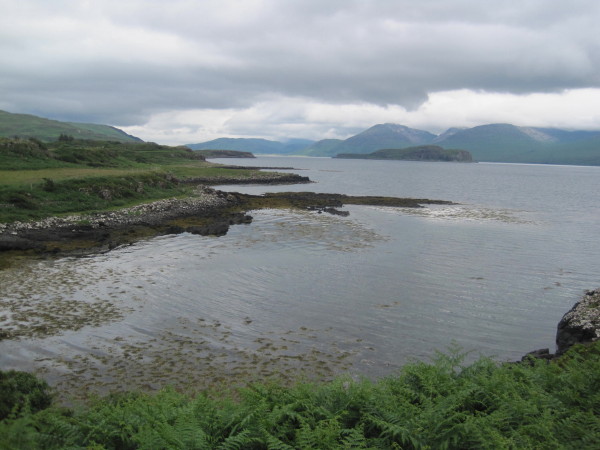
In all probability, Macquarie was born on the island of Ulva, a small island hanging off the side of a slightly larger island, the isle of Mull. Ulva's the source of nothing much but kelp, a few sheep and cattle, potatoes, and Macquaries, never in great numbers, men for a spot of farming, killing, and dying, and women for breeding, holding families together, secretly weeping, and trading for women elsewhere with whom the men could breed.
The people of Ulva lived an incredibly tough and all-too-often short life, as they survived and often failed to survive the freezing winters and the mighty Atlantic storms. The place's only saving grace was the slight climate modification offered by the great Gulf Stream. Even the Macquarie clan chieftain, although wealthy in comparison to his fellow Ulva dwellers, was poor in comparison to his peers on Mull.
However, two sites on Mull are also given as possible birth sites for the lad, albeit more than a little unconvincingly.
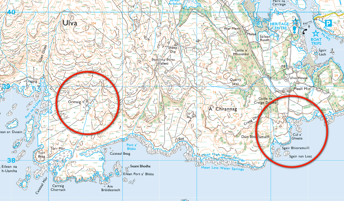
First up, this satellite photo shows the four posited sites, Cùl a' Gheata, Ormaig, Oskamull, and Lagganulva. If it's not already clear, Oskamull and Lagganulva are the two on Mull. I'll look at them first.
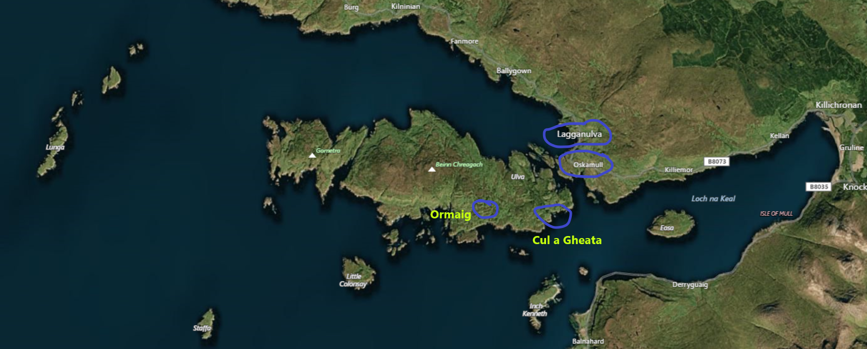
Mull-Based Options for Lachie's Birth
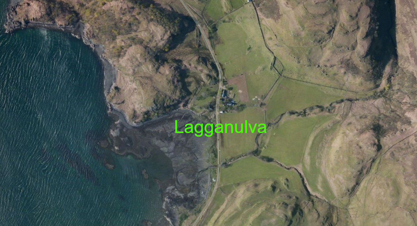
Lagganulva
The cluster of buildings in the middle is the mighty metropolis of Lagganulva. The sites I've come across claiming this as our Lachie's birthplace are unconvincing. However, I've bunged it in here for the sake of verisimilitude and completeness. I can't find any information that indicates Macquarie, his father and/or mother ever lived in this joint. I guess it's possible his mum was caught in Lagganulva while visiting friends or rellies and had to give birth there, but it seems unlikely.
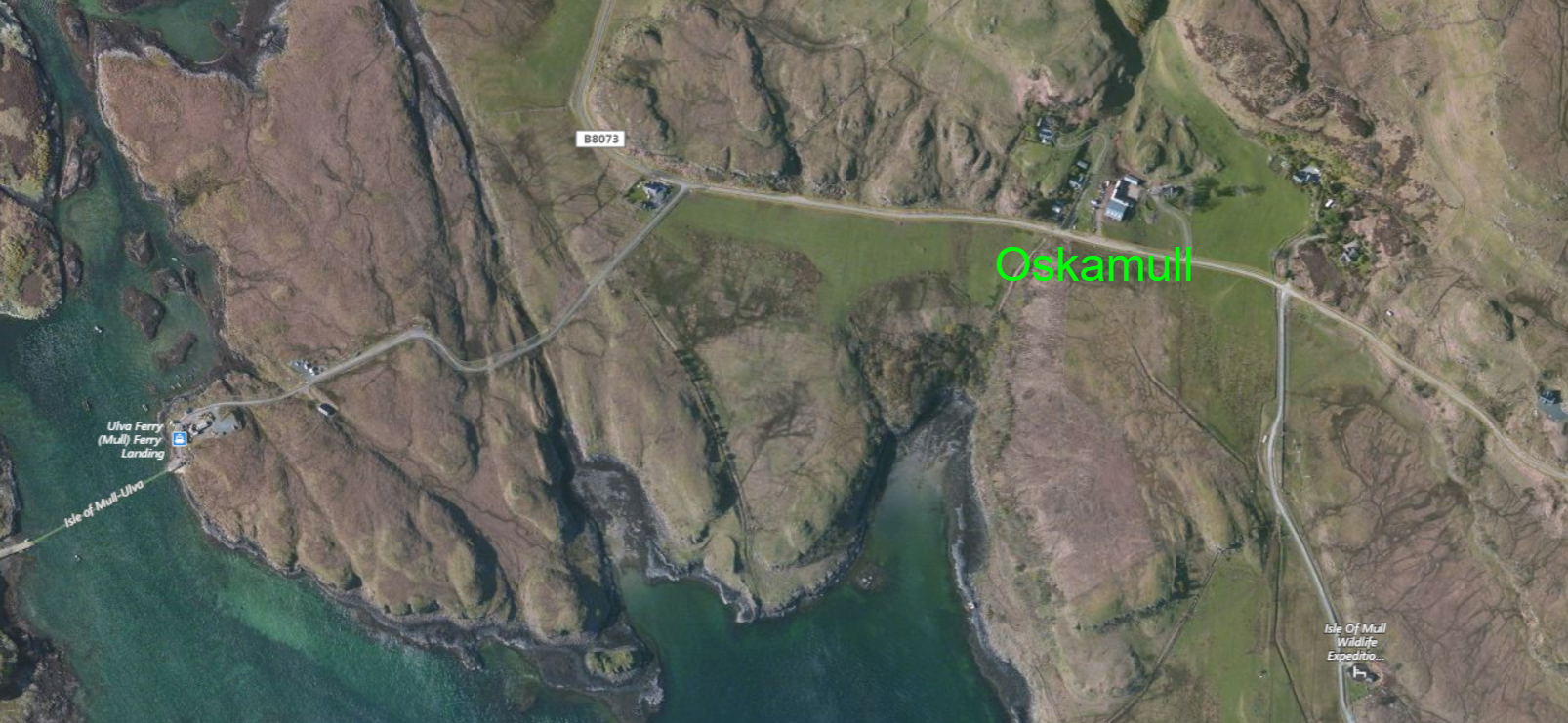
Oskamull
Oskamull's even less prepossessing than Lagganulva, as you can see below. However, it has one, and indeed only, thing making it superior as a choice of Lachlan's birth. That's the fact we know he lived somewhere around here on a tiny bit of land his father rented from the Campbell Earl of Argyle. You can just see the Mull side of the Ulva ferry route down near the bottom left-hand corner. However, it seems unlikely this was his birthplace, and more likely his contact with this place began when he and his family moved here when he was a child.
Ulva-Based Options for Lachie's Birth
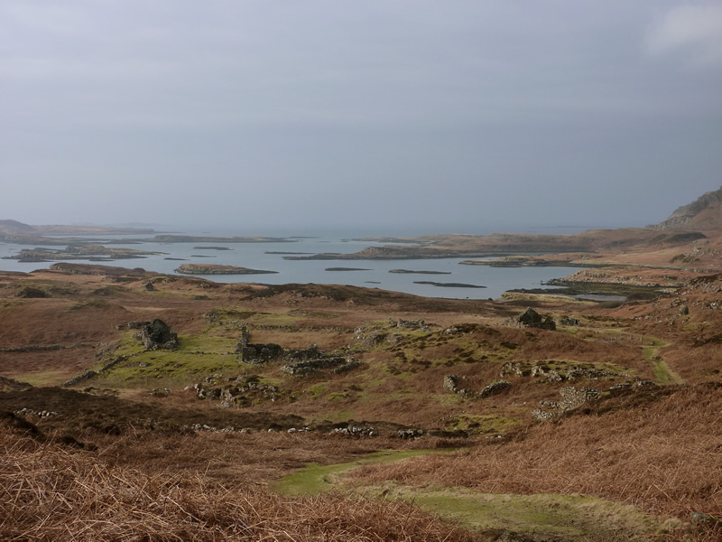
Okey dokey, now we're down to the two most likely possible birthplaces for Lachlan Macquarie. But first, I want to give a bit of an impression of how tough life would have been on Ulva with a satellite image and a map.
First up is a satellite shot of the relevant area. As you can see, the amount of green, or "quality" farmland here is bugger all, and this is probably the most fertile part of the island. To describe those hills as forbidding would be an understatement, and while neither faces directly into the Atlantic, neither has any real protection from the Atlantic storms.
First up is a satellite shot of the relevant area. As you can see, the amount of green, or "quality" farmland here is bugger all, and this is probably the most fertile part of the island. To describe those hills as forbidding would be an understatement, and while neither faces directly into the Atlantic, neither has any real protection from the Atlantic storms.
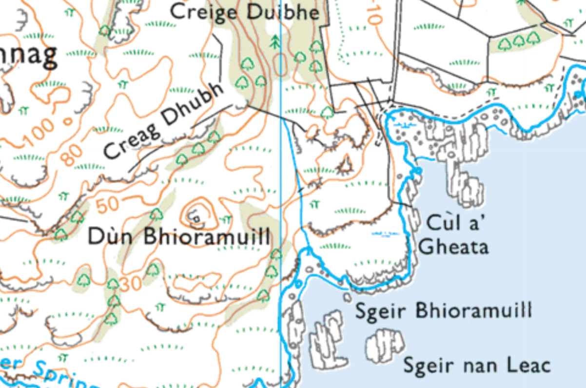
Okay, now for the map.
For those of you unfamiliar with interpreting this type of map, it's called a "contour" map because it includes the light brown lines (or are they orange? I've got red/green colour vision issues!). These lines have numbers on them which in the case of most of the lines on this map indicate the height each line represents above sea level - each line joins places of similar height.
As it happens, the closer together the lines are, the steeper the rise. The contour lines on this map indicate that while the hills may not be amazingly high, they are, in several places, extremely steep. This would be a bugger of a place to walk around, and a terrible place to farm.
Along the coast between Ormaig and Cùl a' Gheata you will see a long line of vertical lines. These represent the island's amazing cliffs. While there are a few, very few, points at which a small boat could pull in, the general nature of the coastline is at least one major indication as to why the people rarely fished. Another being that quantities of fish suitable for eating simply didn't exist anywhere near the island, not because of over-fishing, which wasn't much of an issue in the 18th Century, but because the fish don't want to live there as it doesn't suit them! This was a later cause of a number of people starving to death when the island's owner forced them off their land and then provided them with no assistance while their fate became clear. This was a later owner than the Macquaries, I hasten to add.
One final thing. Where the town of Ormaig was located are very tiny, fairly regularly located squares (more or less!). To the left (that's your left!) you can see more around where the town of Cragaig was located, and once attuned to them you can see others, mostly gathered together in small collections. These represent the remains of the tiny stone-walled cottages in which the people of Ulva lived.
Cùl a' Gheata
This suggested birthplace is about half a kilometre or so straight down from the chieftain's house, or, I should write, where I think the chieftain's house probably was. It's now the site of a 1950s house built to replace a house built after Lauchlan Macquarrie sold the place and while all the other Macquaries and their kith and kin were forced off the land, and/or starved to death while the landowner stood by and watched. By the way, the buildings at the top of the picture below are not Ulva House itself, it's a bit further up.
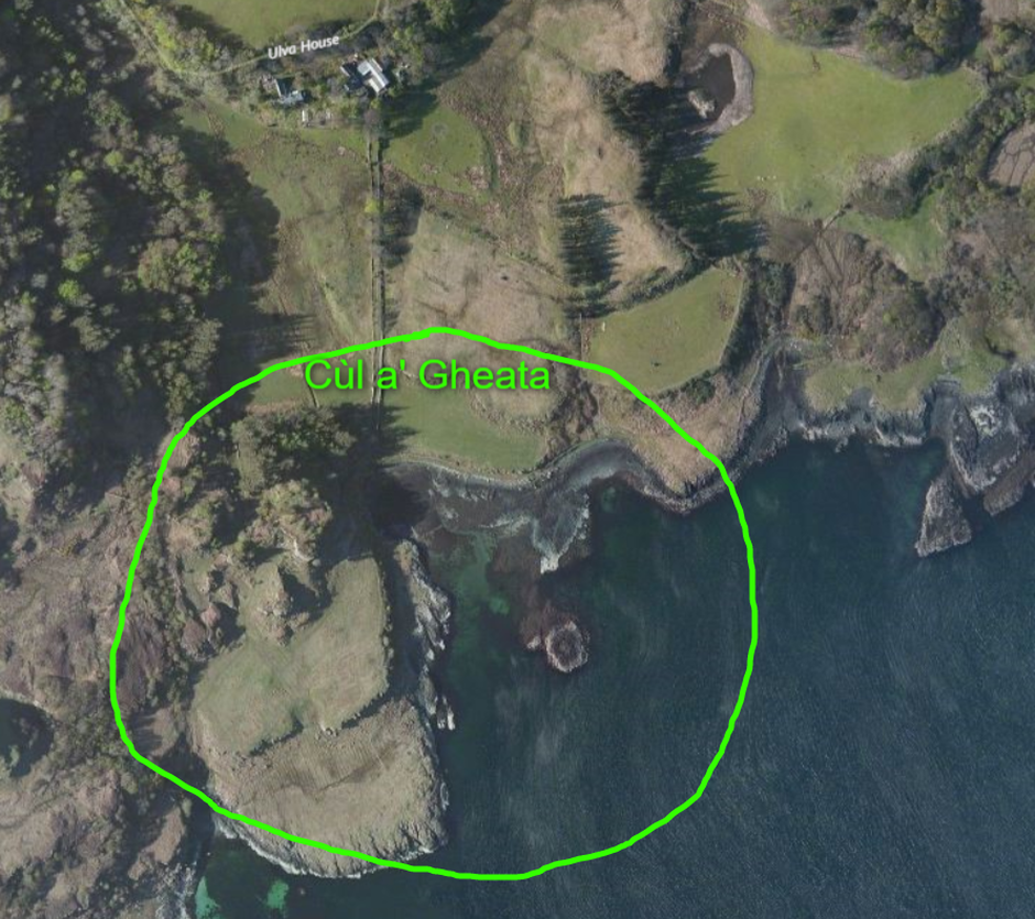
Cùl a' Gheata, from ground level
This is the site most favoured by locals as Macquarie's birthplace. Almost naturally, historians regard Ormaig as most likely. And while I take local opinions very seriously, and would not ordinarily side with the "experts" without strong evidence, in this case, if I had to choose or have my private parts cut off with a butter knife, I would possibly, maybe, perhaps, depending on the wind direction and whether or not the stink is pig poo or Rupert Murdoch, agree with the historians.
My reason is not one of strong evidence, so I'm definitely not saying I or the other historians favouring Ormaig are right, simply that the so-slight-as-to-be-almost-completely-non-existent evidence that exists appears to indicate Ormaig more than Cùl a' Gheata. The reason, at least in my case? I'll come to that in a tick of the old clock. Or I would if clocks and watches actually ticked these days. My watch does, but it's a fake tick. Good grief!
Anyway, we have no clear indication of Macquarie's father's occupation on Ulva. Certainly, when he moved to Oskamull it was to take up a small farm, so it's not impossible that for at least the time of Macquarie's birth, he may have been farming at Cùl a' Gheata.
However, I have a problem. Well, actually I have heaps of them, but one of them actually relates to what I'm writing about now. I come back to my comment in connection with the map of the two possible Ulva birth sites above, in particular regarding the remains of the houses of Ormaig. I've not been on site, so I keep repeating I can't be definite, but I've pored over the maps and photographs of Cùl a' Gheata and I simply can't see anything that even vaguely looks like a house or its remains, let alone a village, however tiny.
But there are some indications he may, for at least a time, have been a miller on Ulva. In those days, in that place, a mill would have been run by water flow. I know the Dutch and others, even in England, used windmills, but I suspect the Atlantic coastline may have been somewhat over-endowed with wind for that option to be practical. But on the map below, while there is a watercourse of some sort on the other side of the headland, there isn't one at Cùl a' Gheata. Of course, as I indicated above, he could have worked here as a farmer, and there are certainly a few patches of arable land there. He may also, of course, have been a farmer in one place, and at a different time a miller somewhere else. But, whatever, the question is, where's the house?
Maybe the house has disappeared for unknown or unclear reasons. For example, it may be under one of the small patches of trees. We simply don't know.
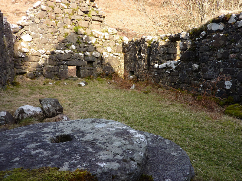
Ormaig
Well, lucky last. What's going for Ormaig? Not much, really, except at Ormaig are the remains of 5 sadly collapsed little houses, and nearby, a short walk along the path towards the almost equally ruined village of Cragaig are the remains of a water mill, a watercourse capable of driving it, and a small dam capable of building the watercourse's driving power - which it would have needed even for the comparatively small mill stones pictured below. This mill is actually closer to Cragaig than Ormaig, so why don't people claim Lachlan was born at Cragaig? I'm afraid I have no answer for that, and make the point that apparently (and I stress "apparently") most locals reckon he wasn't born in either. But, then, there's not a soul left on the island who would have known someone who knew someone etc., and hasn't been for well over 150 years.
Anyway, if at any time Lachlan Macquarie's dad, Lachlan Macquarie (I kid you not!), not to be mistaken for the clan chieftain Lauchlan Macquarrie (!), was a miller (and there's no evidence really, apart from "stories", which, sadly, become self-referencing after a while), then Ormaig is a place he could have carried out that work. But, so also is Cragaig! So, additional to the lack of evidence Lachlan senior (as opposed to Lauchlan senior - good grief!) was a miller here, or anywhere else for that matter, I also haven't seen any evidence as to whether or not this was the only mill on the island!
Anyway, if at any time Lachlan Macquarie's dad, Lachlan Macquarie (I kid you not!), not to be mistaken for the clan chieftain Lauchlan Macquarrie (!), was a miller (and there's no evidence really, apart from "stories", which, sadly, become self-referencing after a while), then Ormaig is a place he could have carried out that work. But, so also is Cragaig! So, additional to the lack of evidence Lachlan senior (as opposed to Lauchlan senior - good grief!) was a miller here, or anywhere else for that matter, I also haven't seen any evidence as to whether or not this was the only mill on the island!
Anyway, to sum up. Why do I reckon Ormaig's more likely than Cùl a' Gheata? Three things, it has:
And why do I think Ormaig's more likely than Cragaig? Well, I don't. So there!
- the clear remains of 5 sadly collapsed little houses, if "house" is at all a suitable word for the huts these places really were;
- the clear remains of a mill; and
- a watercourse capable of operating as a millstream.
And why do I think Ormaig's more likely than Cragaig? Well, I don't. So there!
Ormaig, or what's left of it after the cruel clearing of the people by a rapacious landlord with the reputation of being the cruellest of all the bastards who performed this genocidal act in Scotland. Although, I have to write, for truth's sake, he has been marginally rehabilitated by revisionist historians in recent times. However, I maintain that benefits accruing to these peoples' descendants do not justify an act of genocide - or any other act of cruelty, if the term "genocide" is regarded as over-stated.
Is the lack of proof of place of birth an issue?
Is it the end of the world if we don't know the precise place of our Lachlan's birth? No, of course not. And perhaps only an obvious history nerd like me would even bother commenting on it. But it does irritate me when I go online and various websites which obviously purport to possess some expertise make precise claims about things that are far from known in reality.
M'Quarrie's house was mean ...
Boswell, J. (1810). The Journal of a Tour to the Hebrides, with Samuel Johnson, L,L.D. containing some poetical pieces by Dr. Johnson, relative to the tour, and, never before published: a series of his conversation, literary anecdotes, and opinions of men and books: with an authentic account of the distresses and escape of the grandson of King James II, in the year 1746. From the London edition, revised and corrected by the author. Philadelphia: John F. Watson, 98 South Second Street, p.307.
The house and the furniture are not always nicely suited. We were driven once, by missing a passage, to the hut of a gentleman, where, after a very liberal supper, when I was conducted to my chamber, I found an elegant bed of Indian cotton, spread with fine sheets. The accommodation was flattering; I undressed myself, and felt my feet in the mire. The bed stood upon the bare earth, which a long course of rain had softened to a puddle.
Johnson, S. (1791). A Journey to the Western Islands of Scotland, A New Edition. London: A Strahan & T Cadell, The Strand, p.233.
We had each an elegant bed in the same room; and here it was that a circumstance occurred, as to which he has been strangely misunderstood. From his description of his chamber, it has erroneously been supposed, that his bed being too short for him, his feet, during the night, were in the mire; whereas he has only said, that when he undressed, he felt his feet in the mire: that is, the clay-floor of the room, on which he stood before he went into bed, was wet, in consequence of the windows being broken, which let in the rain.
Boswell, J. Op. Cit. p.310
